May 2, 2010 - Day 17

This was going to be a short day as far as traveling was concerned. The plan is to ride the incoming tide up the Cape Fear River and through Snow’s Cut. We departed at 0930 (about 2 hours before high tide) and got out into the river. Once we were out in the current our speed jumped from 6.0 mph to 9.7 mph. It was an easy run over to Carolina Beach where we anchored about 1200.


Being for the first to arrive, we had the anchorage area to ourselves. Things were pleasant for a while and then the winds began to pipe up. At 1500, the wind was gusting to 25. Thankfully, the Rocna was holding firm according to the GPS.


Location: Anchored at Carolina Beach, NC - MM 295
Distance Traveled: 14 mi

May 1, 2010 - Day 16

We took it easy this morning and waited for the tide level to rise a bit. We were only going a short distance to Southport and I did not want to start the day by running aground on the bar going out the harbor or several of the inlets ahead. We got underway about 0930 and headed for two notorious troublespots, Shallote and Lockwoods Folly Inlets. These inlets were dredged recently, but are reported as shoaling again already.


We arrived a little early for the scheduled opening of the Sunset Beach Pontoon Bridge. It's another very old bridge being replaced with a new high rise span presently under construction. I wonder if it will stay in place after the new high rise is completed?


Our timing with the tide provides us with plenty of water and we transit the troublespots easily. It being the weekend, we were bothered more by the local traffic. Using the autopilot was near impossible as we got waked from both sides as boats literally flew by us in both directions.


The wind is really up and out of the SW so water depths seem to be below normal. This means anchoring in Dutchman Creek or the Pipeline Canal are out of the question. We head on to the limited anchorage in the old Southport basin and the free docks at the Provision restaurant. Unfortunately we are late arrivals and those areas are already filled by other boats. With our cheap choices exhausted, we contact Southport Marina and take a slip there for the night.


We are docked by 1500 and decide to use the remainder of the day for doing laundry and taking showers. While doing laundry, we encounter a couple of retired ministers we met in Stuart. They are doing the Great Loop on board a large houseboat. It was great to sit and talk with them again.


The evening was pleasant and we both fell asleep watching TV, then got up and went to bed for the night.


Location: Southport Marina, Southport, NC - MM 309 (N of Myrtle Beach, SC)
Distance Traveled: 37 mi

April 30, 2010 - Day 15

No overnight happenings to speak of but we had more fog this morning. In fact, at 0600 when I got up, I could only see the mast of the other sailboat sticking above the fog. We decided to have coffee and a regular breakfast while we waited for the fog to lift. The fog cleared out enough to hoist the anchor and get underway about 0815.

We continued our scenic tour of the Waccamaw until the ICW branched off into the cut toward Myrtle Beach and the Little River. The cut is narrower and littered with “blue collar pieces of heaven” and overstated opulence. Bridge operators at Socastee, Barefoot Landing and Little River did their best to slow us down by making us wait 10 to 15 minutes for each opening. These are tired old swing bridges and have all been replaced by nearby high rise bridges. I’m sure the justifications for building the new bridges included getting rid of these decrepit swing bridges. Why are they still in existence?

As we are departing Myrtle Beach we hear chatter on the VHF regarding the number of boats in the Calabash Creek anchorage. This was to be our destination but it was already crowded so we opted to stay at the Myrtle Beach Yacht Club.


The tide was low and water depths into the harbor basin were very skinny. Darn near heart stopping at one point. Even at the dock we were very close to sitting on the bottom. We refueled and prepped the boat for the next day and then hit the showers.


We were both a little tired so instead of fixing dinner, we decided to go to the Officer’s Club Restaurant. We were presently surprised. The atmosphere and food were great. We both had excellent meals. We had crab stuffed mushrooms, steak, and shrimp scampi,. We even decided to have desert and enjoyed a “Brownie Tower” with coffee. After the fabulous meal we walked a bit and then headed back to the boat near 2200.


It was a quiet evening dockside.

Location: Myrtle Beach Yacht Club, SC - MM 346 (N of Myrtle Beach, SC)
Distance Traveled: 43 mi

April 29, 2010 - Day 14

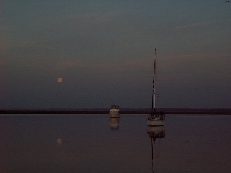
Big moon shining all night gave us a beautiful view of the anchorage. It also helped us keep our visual location reference points. Two other boats with us in the anchorage overnight, one trawler and one sailboat. The wind died way down late in the evening so we had a peaceful night. This morning however, we had a little bit of fog. I got these great pictures of the moon setting and the sun rising within minutes of each other. We delayed our start a little, but we were underway at 0815 headed for the scenic Waccamaw River and Myrtle Beach.
We got some boost from the current until we reached Winyah Bay. From there we fought the strong current coming down the Waccamaw. The wind was light and from dead astern until late in the afternoon. By the time the wind began to increase, we decided to stop short of our goal and anchor in Thouroghfare Creek to take advantage of the trees that provided some wind protection there.

We shared the anchorage with one other sailboat. We dropped the hook about 1615 and found out why its called “Thoroughfare”. There was lots of local traffic running between the Waccamaw River and the Great Pee Dee River plus the usual local fishermen, skiers and jet skis.

Thankfully, the wind and traffic died a little after sundown and we had a quiet evening.


Location: Thoroughfare Creek, SC - MM 389 (N of Georgetown, SC)
Distance Traveled: 47 miles