We’re up early with coffee and a breakfast bar to start the day. We get underway at 0620 hoping to make all the bridges before the late afternoon opening restrictions. Unfortunately, all the fast powerboats had the same idea. A few got going before us, but we had to put up with all the others passing/waking us the rest of the day.
The overcast skies gave way to partly sunny and then sunny as we got into Virginia waters. We arrived at the North Landing Bridge a few minutes early and had to jockey about. Once we cleared the bridge, the race was on to make the rest of the scheduled openings at Centerville, Great Bridge, the lock, Steel Bridge and Gilmerton.
At the lock we were the last boat in and were forced to take a port side tie up. There were no line handlers to help and we struggled to get lines on the cleats. Being the last boat out of the lock, we kept the RPMs up as we raced to make the Steel Bridge opening.
After clearing Steel Bridge we ran into a show stopper at the #7 railroad bridge adjacent to the Gilmerton. The normally open RR bridge was down and they were doing maintenance. Ten boats jockeyed about for over thirty minutes before maintenance crews announced they would open. We cleared the RR and Gilmerton and continued on.
The skyline had changed only a little. The one glaring difference was the absence of the old Jordan Bridge. It wasn’t totally gone, but the span, counterweights, and half of one tower were gone. In fact, welder/burners were cutting away on one tower as we passed by.
When we reached our dock, the transmission refused to shift out of reverse and we crashed the dock stern first. We were going slow and suffered no damage except to my pride. We traveled 2000+ miles, made dozens of successful dockings or mooring approaches and then we hit the dock arriving at home. Audience…you betcha!!! The whole world will know and remember not our cruising accomplishments, just our arrival home! Sheez!
Regardless, We’re HOME!
Location: PYC Dock/Home - Portsmouth, VA - MM 0
Distance Traveled: 50 mi
Total Boat mileage on return trip: 1058 statute miles
May 13, 2010 - Day 28
The predicted seas for the Albemarle was 1-2 feet with winds of 10-15 from the NE. Not a great forecast, but we decided to attempt a crossing of the infamous Albemarle Sound. Sometimes I think I’d like to take those NOAA weather guessers out to experience their predictions. We successfully negotiated the nasty shoals just north of the Alligator River Bridge and then began experiencing winds of 20 with higher gusts. Waves ran 3-4’ (seemed like mostly 4’) with a short period between making it a bone jarring, very rough and slow crossing. Donna stayed in the cockpit as conditions below were intolerable. Buddy took refuge in his cubby hole under the dinette next to the hull. Being at the center of the boat, he got lots of rocking action but wasn’t tossed about so much. Surprisingly, he did not get seasick today.
Conditions did not get much better until we reached the upper portions of the North River. The sky remained overcast and the temperature cool all day. It took a sweatshirt and my heavier foul weather gear to stay comfortable against the wind and spray. We heard several boats calling Sea Tow and Towboat/US for assistance during the day. Rough conditions seem to always increase the occurances of equipment failures.
When we reached the anchorage area at Buck Island, we decided to continue on to Midway Marina at Coinjock, NC. Doing so would put us about an hour and a half of travel time closer for tomorrows run home. Considering the number of restricted bridges and the lock to be timed, we needed that advantage.
We arrived at Midway Marina about 1600 and got a tie -up on the face dock. After straightening up the interior of the boat, we proceeded to the showers for a cleanup before dinner.
We went next door to Crabbie’s Restaurant for dinner. The service left something to be desired, but our NC BBQ dinners were delicious and plentiful. Back at the boat, we watched a little TV before we both fell asleep. What a day!
Location: Midway Marina, Coinjock, NC - MM 50
Distance Traveled: 34 mi
May 12, 2010 - Day 27
We awoke early (thanks to Buddy) to a beautiful morning. The temperature was in the mid 60s and the humidity had not started to climb. We took the time to enjoy a quick breakfast and then started the departure drill. The anchor was up at 0645 and we were on our way.
 It was a short run from the anchorage to the southern entrance to the Alligator River/Pungo River Canal. The canal is usually quite boring, but this morning we encountered a number of deer down at the waters edge on several occasions.
As we continued the 20+ mile run through the canal, the temperature and winds began to increase. When we reached the Alligator river around 1100, the wind was screaming 20+ out of the SW. This meant a lumpy ride up the river with the wind driven waves smacking the port quarter. It sure would be nice to get a decent day of sailing or motoring for that matter.
The weather report calls for storms and gusting (no kidding!!) winds as we approached the Alligator River Bridge. That triggered our decision to pull into the Alligator River Marina for the night. We reached the marina and are docked at 1515.
We find several boats from the anchorage the night before. Everyone had the same idea…avoid the afternoon storms and high winds. “Shingebiss” a trawler with friends we met at River Dunes pulled in about an hour later and we had a nice reunion chat.
A little wind down time, a nice dinner, a hot shower and we settle in for the evening hoping the winds are more favorable for our dash across the Albemarle Sound tomorrow.
Location: Alligator River Marina, NC - MM 84
Distance Traveled: 43 mi
May 11, 2010 - Day 26

We decide to try leaving anyway and get underway about 0745. The wind is blowing about 15 with gusts to 20 and we encounter 2-3’ waves as we reach the ICW. It’s better than yesterday, but not by much.
We hang tough and make the turn at Maw Point and enter the Bay River. We are now running with the wind and following seas. Rolling out the jib makes things are a little easier, but lots of howling below means Buddy has gotten seasick. Yuck!
When we reached the Hobucken Canal, things settled down for a while but the calm was short lived when we reached the Pamlico River. It was a 5+ mile run across the river and into the Pungo River. The turn up the Pungo provided little relief until we neared the town of Belhaven. The eastward turn at Belhaven provided the best sailing we had experienced all day.
When we reached the western end of the Alligator River/Pungo River Canal, we decided to anchor in a nearby anchorage for the evening. We found 4 other boats already in the anchorage but were able to squeeze in and dropped the hook at 1545.
Location: Pungo River, East of Belhaven, NC - MM 127
Distance Traveled: 47 mi
May 10, 2010 - Day 25
Departed the marina at 0745 and headed toward the ICW. Winds are really up. By the time we reach the ICW magenta line, the wind is blowing 20+ and gusting above 25. Waves are 3'+ and on the nose. We are only making 3.5 mph against the wind so I decide to return to Broad Creek and wait for this mess to blow itself out.
Location: Anchored again in Broad Creek, North of Oriental, NC - MM 174
Distance traveled: 7mi (but it doesn’t count)
Location: Anchored again in Broad Creek, North of Oriental, NC - MM 174
Distance traveled: 7mi (but it doesn’t count)
May 8 & 9, 2010 - Day 23 & 24
We awoke to increasing winds out of the SW and predictions of gusts to 25. We decided to move across the river to River Dunes Marina with its deeper water and protection.
We arrived there about 1030 and found several other cruisers hunkering down to wait for calmer conditions on the Neuse River. River Dunes is a “planned resort community” with a marina. The marina has all upscale amenities but is reasonably priced. It’s only negative is the approximately four mile run off the ICW route.
Location: River Dunes Marina, North of Oriental, NC - MM 17
May 7, 2010 - Day 22

I once overheard a fellow cruiser ask, “Will we ever get a favorable current?” Well today wasn’t the day either. The journey to the “non-tidal” zone was a battle today. As we traversed Core Creek and Adams Creek Canal the current was rushing towards the Beaufort Inlet. At one point our speed was down to less than 4 mph. Even the wind direction would not allow us to motor sail and assist our speed.
When we reached the Neuse River, it was apparent we were not going much further today. The wind was blowing 15+ from the NE and waves were 2-3 feet. A lumpy, not so pleasant Neuse awaited. So much for the “weather guessers” prediction of SW breezes. We motor jibbed across and as northward as possible. Then we turned into the wind and motored on to the entrance of Broad Creek. We entered the creek and headed to R4 and the anchorage there.
The water level in the anchorage seemed more shallow than in our previous visits. We were somewhat exposed to the NE wind, but conditions were tolerable. There were two shallow draft powerboats anchored further in and later, another sailboat anchored near us.
At dusk the wind switched directions and moved to the SW. This was not good as it moves water out of the creek and the water levels drop. We had anchored in 6.5’ of water which slowly became 5’ as the evening progressed.
Location: Broad Creek, North of Oriental, NC - MM 174
Distance Traveled: 26 mi
May 6, 2010 - Day 21
Around 0900 we started moving across the water to the town of Beaufort. We have always heard a lot of positive info from other cruisers about the town. To avoid the Beaufort bascule bridge, which was undergoing some maintenance, we took the main channel headed toward the inlet, then rounded Radio Island and headed back north into Beaufort.
 The anchorage was extremely crowded so we took a slip at the Beaufort Docks. The floating docks and dock side help made docking easy. After a little cleanup, we took a walking tour of the town.
 Front street has lots of restaurants and shops which liberated some of our wallet contents. The real interesting part of town starts in the block behind the “getcha” zone. There we found lots of historic homes, a graveyard, a couple of working artists’ studios and a maritime museum.
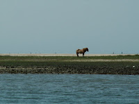 By mid-afternoon we had pretty much seen it all so we walked back to Front Street and had a late lunch at the Dock House Restaurant. It was a pleasant experience dining al fresco with views of the harbor, docks, and wild horses on the island across the harbor.
We did have a couple of negative experiences with the dock management. We requested a pump out as we were arriving and were informed the pump out dock was blocked by large motor vessel. They expected the boat to leave later. It didn’t leave and they let them continue to block the pump out service until the next morning. We were not the only customers denied pump out services. The other issue involved getting fuel. The advertised “fuel at your slip” was not to be had and required moving to yet another dock for fuel service. Most marinas have the pump out and fuel at the same dock.
As we were clearing our slip the next morning, the motor vessel finally moved off the pump out dock so we slipped in real quick, got the pump out and then moved over to the fuel dock to fill up.
Location: Beaufort Docks, Beaufort, NC - MM 200
Distance Traveled: 4 mi
May 5, 2010 - Day 20
More fog this morning. Visibility is about 1 mile when boats start leaving the anchorage. We weighed anchor and start moving north about 0720. One bridge to clear this morning at Onslow Beach. It was a struggle and I ran the engine harder than I like to but we make it to the bridge in time for the 0800 opening. There were nine boats jockeying about waiting on the old swing bridge to finally get fully open and then everyone took off.
 About a mile north of the bridge, the fog closed in and visibility drops to 150 yards. Suddenly nine boats came to a crawl. I had all my running/steaming lights on but cannot see any lights on the boats ahead. I can barely make out the shape of the boat ahead of me and I am thankful to be the last boat in line. This is definitely when having radar would be helpful.
After 0930, the fog began to clear a little and we picked up speed. We struggled against the current as we approach Bogue Inlet and Swansboro. We entered Bogue Sound where the channel is narrow but fairly straight. We got a little breeze and did some motor jibbing. We soon crossed the tide line and begin fighting the incoming tidal current from the inlet at Beaufort.
Around 1100 or so, the wind turned cool and began to pickup. Fog began coming in and obscured the Emerald Island and Bogue Banks to the south. As the fog rolled across the sound toward us visibility got less and less. When we finally reached the Atlantic Beach Bridge, we could not see the land mass to our south.
Things looked better as we approach Morehead City. From the big channel I saw two sailboats at the Sanitary Restaurant dock. That meant 2 of the 3 so called “free docks” were taken. Having learned our lesson on the last trip, we avoided the shoaled small northeast channel and took the main channel to the port area and round Sugar Loaf Island to the Sanitary.
 Once docked we took a walk about town and explored the construction at the Municipal Dock area. The town is building a Shower/Restroom/Laundry facility next to the docks. This should make these docks another possible stopping area. We also checked out a few shops including a great upscale bakery/gourmet foods place.

 After the walk we dined at the Sanitary to qualify for the “free” ($10) slip usage. Next door at a newly opened place called Jack’s, there was quite a Cinco de Mayo celebration going on. A live band, lots of hot rod cars, custom motorcycles, and a celebrity of sorts. Mikey Teutul from Orange County Choppers and the TV show “American Chopper” was there with some of their custom bikes.

After 0930, the fog began to clear a little and we picked up speed. We struggled against the current as we approach Bogue Inlet and Swansboro. We entered Bogue Sound where the channel is narrow but fairly straight. We got a little breeze and did some motor jibbing. We soon crossed the tide line and begin fighting the incoming tidal current from the inlet at Beaufort.
Around 1100 or so, the wind turned cool and began to pickup. Fog began coming in and obscured the Emerald Island and Bogue Banks to the south. As the fog rolled across the sound toward us visibility got less and less. When we finally reached the Atlantic Beach Bridge, we could not see the land mass to our south.
Things looked better as we approach Morehead City. From the big channel I saw two sailboats at the Sanitary Restaurant dock. That meant 2 of the 3 so called “free docks” were taken. Having learned our lesson on the last trip, we avoided the shoaled small northeast channel and took the main channel to the port area and round Sugar Loaf Island to the Sanitary.


 After the walk we dined at the Sanitary to qualify for the “free” ($10) slip usage. Next door at a newly opened place called Jack’s, there was quite a Cinco de Mayo celebration going on. A live band, lots of hot rod cars, custom motorcycles, and a celebrity of sorts. Mikey Teutul from Orange County Choppers and the TV show “American Chopper” was there with some of their custom bikes.
 Location: Sanitary Restaurant Dock, Morehead City, NC - MM 205
Distance Traveled: 39 mi
May 4, 2010 - Day 19

Light drizzle started about 0500 this morning and things went down hill from there. By the time it would have been getting light, fog settled in and visibility was way down. A check of the internet radars said more heavy rain was to come.
We decided to take the day off. We enjoyed a leisurely breakfast with a great omelet and lots of hot coffee. Later Donna worked on her art stuff while I made log entries.


Location: Still Anchored in Mile Hammock Bay, NC - MM 244
Distance Traveled: None
May 3, 2010 - Day 18
We got a late, 0730, start today. I wanted to be underway at 0700 so we could time the bridges we had to transit. The late start caused us to arrive early/late at the Wrightsville Bridge. I tried dragging my heals by idling the engine back and even idled back and put the transmission in neutral. The wind was directly behind us blowing 18, gusting to 22. Add that to the favorable current and the boat was traveling at 4.3 mph with no engine or sail help.
 Arriving at bridges with lots of wind and current is no fun. Heading into the wind/current with just enough speed to keep the boat near stationary is not too hard. But when you get inexperienced skippers or big powerboats who cant idle low enough, it becomes a dance of sorts as you try to maintain position and dodge boats out of control.
After getting through the Wrightsville Bridge, we played the same game again trying unsuccessfully to arrive just in time for the opening of the Figure Eight Island Bridge. After watching us jockey around for about 15 minutes in wind gusting 24, the bridge operator said he would try to open the creaky old swing span early. By the time he got it open, it was at the normal scheduled time.
The next bridge at Surf City was 18 miles away. The GPS estimated with our speed we would be either 20 minutes late or 40 minutes early depending on how you looked at it. No amount of sail trim and safe throttle could get us there any faster so we settled back and dragged our heals again.
 When we got to our anchorage destination, Mile Hammock Bay, there were already 5 boats anchored. We found a spot and dropped the hook at 1630. The bay is a basin dredged out by the Marine Corps for use with Camp LeJune. By 1800 three more boats joined the anchorage making a total of nine boats (make that ten counting the permanent resident). Considering the high wind situation (20 gusting to 24) we all needed maximum swing room.
The wind stayed strong until sometime after 0130. The Rocna held firm with a 5:1 scope.
Location: Anchored in Mile Hammock Bay, NC - MM 244
Distance Traveled: 51 mi

After getting through the Wrightsville Bridge, we played the same game again trying unsuccessfully to arrive just in time for the opening of the Figure Eight Island Bridge. After watching us jockey around for about 15 minutes in wind gusting 24, the bridge operator said he would try to open the creaky old swing span early. By the time he got it open, it was at the normal scheduled time.
The next bridge at Surf City was 18 miles away. The GPS estimated with our speed we would be either 20 minutes late or 40 minutes early depending on how you looked at it. No amount of sail trim and safe throttle could get us there any faster so we settled back and dragged our heals again.

The wind stayed strong until sometime after 0130. The Rocna held firm with a 5:1 scope.
Location: Anchored in Mile Hammock Bay, NC - MM 244
Distance Traveled: 51 mi
May 2, 2010 - Day 17
This was going to be a short day as far as traveling was concerned. The plan is to ride the incoming tide up the Cape Fear River and through Snow’s Cut. We departed at 0930 (about 2 hours before high tide) and got out into the river. Once we were out in the current our speed jumped from 6.0 mph to 9.7 mph. It was an easy run over to Carolina Beach where we anchored about 1200.
 Being for the first to arrive, we had the anchorage area to ourselves. Things were pleasant for a while and then the winds began to pipe up. At 1500, the wind was gusting to 25. Thankfully, the Rocna was holding firm according to the GPS.
Location: Anchored at Carolina Beach, NC - MM 295
Distance Traveled: 14 mi

Location: Anchored at Carolina Beach, NC - MM 295
Distance Traveled: 14 mi
May 1, 2010 - Day 16
We took it easy this morning and waited for the tide level to rise a bit. We were only going a short distance to Southport and I did not want to start the day by running aground on the bar going out the harbor or several of the inlets ahead. We got underway about 0930 and headed for two notorious troublespots, Shallote and Lockwoods Folly Inlets. These inlets were dredged recently, but are reported as shoaling again already.
 We arrived a little early for the scheduled opening of the Sunset Beach Pontoon Bridge. It's another very old bridge being replaced with a new high rise span presently under construction. I wonder if it will stay in place after the new high rise is completed?
Our timing with the tide provides us with plenty of water and we transit the troublespots easily. It being the weekend, we were bothered more by the local traffic. Using the autopilot was near impossible as we got waked from both sides as boats literally flew by us in both directions.
The wind is really up and out of the SW so water depths seem to be below normal. This means anchoring in Dutchman Creek or the Pipeline Canal are out of the question. We head on to the limited anchorage in the old Southport basin and the free docks at the Provision restaurant. Unfortunately we are late arrivals and those areas are already filled by other boats. With our cheap choices exhausted, we contact Southport Marina and take a slip there for the night.
We are docked by 1500 and decide to use the remainder of the day for doing laundry and taking showers. While doing laundry, we encounter a couple of retired ministers we met in Stuart. They are doing the Great Loop on board a large houseboat. It was great to sit and talk with them again.
The evening was pleasant and we both fell asleep watching TV, then got up and went to bed for the night.
Location: Southport Marina, Southport, NC - MM 309 (N of Myrtle Beach, SC)
Distance Traveled: 37 mi
April 30, 2010 - Day 15
No overnight happenings to speak of but we had more fog this morning. In fact, at 0600 when I got up, I could only see the mast of the other sailboat sticking above the fog. We decided to have coffee and a regular breakfast while we waited for the fog to lift. The fog cleared out enough to hoist the anchor and get underway about 0815.
 We continued our scenic tour of the Waccamaw until the ICW branched off into the cut toward Myrtle Beach and the Little River. The cut is narrower and littered with “blue collar pieces of heaven” and overstated opulence. Bridge operators at Socastee, Barefoot Landing and Little River did their best to slow us down by making us wait 10 to 15 minutes for each opening. These are tired old swing bridges and have all been replaced by nearby high rise bridges. I’m sure the justifications for building the new bridges included getting rid of these decrepit swing bridges. Why are they still in existence?
As we are departing Myrtle Beach we hear chatter on the VHF regarding the number of boats in the Calabash Creek anchorage. This was to be our destination but it was already crowded so we opted to stay at the Myrtle Beach Yacht Club.
The tide was low and water depths into the harbor basin were very skinny. Darn near heart stopping at one point. Even at the dock we were very close to sitting on the bottom. We refueled and prepped the boat for the next day and then hit the showers.
 We were both a little tired so instead of fixing dinner, we decided to go to the Officer’s Club Restaurant. We were presently surprised. The atmosphere and food were great. We both had excellent meals. We had crab stuffed mushrooms, steak, and shrimp scampi,. We even decided to have desert and enjoyed a “Brownie Tower” with coffee. After the fabulous meal we walked a bit and then headed back to the boat near 2200.
It was a quiet evening dockside.
Location: Myrtle Beach Yacht Club, SC - MM 346 (N of Myrtle Beach, SC)
Distance Traveled: 43 mi

As we are departing Myrtle Beach we hear chatter on the VHF regarding the number of boats in the Calabash Creek anchorage. This was to be our destination but it was already crowded so we opted to stay at the Myrtle Beach Yacht Club.
The tide was low and water depths into the harbor basin were very skinny. Darn near heart stopping at one point. Even at the dock we were very close to sitting on the bottom. We refueled and prepped the boat for the next day and then hit the showers.

It was a quiet evening dockside.
Location: Myrtle Beach Yacht Club, SC - MM 346 (N of Myrtle Beach, SC)
Distance Traveled: 43 mi
April 29, 2010 - Day 14
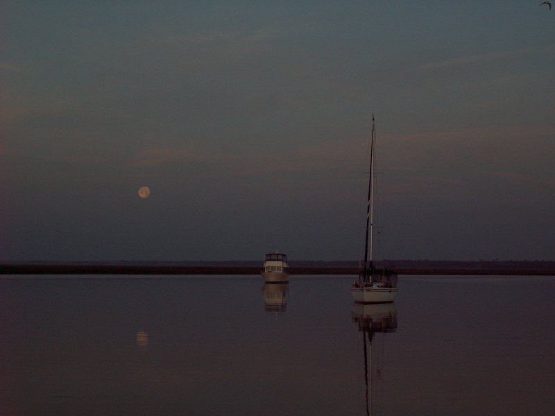
Big moon shining all night gave us a beautiful view of the anchorage. It also helped us keep our visual location reference points. Two other boats with us in the anchorage overnight, one trawler and one sailboat. The wind died way down late in the evening so we had a peaceful night. This morning however, we had a little bit of fog. I got these great pictures of the moon setting and the sun rising within minutes of each other. We delayed our start a little, but we were underway at 0815 headed for the scenic Waccamaw River and Myrtle Beach.
 We got some boost from the current until we reached Winyah Bay. From there we fought the strong current coming down the Waccamaw. The wind was light and from dead astern until late in the afternoon. By the time the wind began to increase, we decided to stop short of our goal and anchor in Thouroghfare Creek to take advantage of the trees that provided some wind protection there.
We shared the anchorage with one other sailboat. We dropped the hook about 1615 and found out why its called “Thoroughfare”. There was lots of local traffic running between the Waccamaw River and the Great Pee Dee River plus the usual local fishermen, skiers and jet skis.
Thankfully, the wind and traffic died a little after sundown and we had a quiet evening.
Location: Thoroughfare Creek, SC - MM 389 (N of Georgetown, SC)
Distance Traveled: 47 miles
April 28, 2010 - Day 13
Today was full of adventures. We get underway at 0700. A little boost from the current helped us reach Elliotts Cut ahead of schedule. We shot through the cut on the ebbing current and then had to slow down to time the passage through the Wappoo Creek Bridge. While waiting for the bridge, we were boarded by the "coasties". The did their usual Q&A check and inspected for the required safety equipment. We passed. They got off the boat just in time for us to make the bridge opening.
 We had a great run through the Charleston Harbor. After that it was skinny water almost all the way to our anchorage . We bumped bottom several times and went real slow searching for the deeper water. We happened upon a boat hard aground after the Ben Sawyer Bridge. Don't know if he got out of the channel and ran aground or if he tried to anchor overnight and drifted into the shallows. Six to eight foot tide swings are nothing to take lightly. The fellow ran behind the boat when he saw Donna taking pictures. I believe I'd hide my face too.
We finally arrived at the anchorage here in Awendaw Creek about 1745. It’s a great anchoring spot except for the fast tidal current. Tonight we have current and a breeze (15 gusting to 18) that just won’t quit. I guess I’ll be up all night checking for anchor drag even with the new Rocna. Yep nervous Nellie, that’s me.
Location: Awendaw Creek, SC - MM 446 (N of Charleston, SC)
Distance Traveled: 61 mi
April 27, 2010 - Day 12
We’re up at 0630 and head for the showers. The swing bridge is closed to traffic until 9AM so we have time to shower and get the holding tank pumped out before we leave. We get underway about 0825 and arrive at the bridge just in time for the opening.
The wind was really up today. Blowing 20, gusting to 25+, from the west is not a good thing. It blows the water out and we already have several skinny water sections to navigate. We managed to make it through the Ashepoo-Coosaw Cut 3 hours before MLW. From there we battled the wind and current the rest of the day.
We pulled into Tom Point Creek and had to run 2+ miles upstream before we found a spot with some trees to block the still gusting wind. We dropped the hook and were done for the day at 1633. Two other boats joined us later, one upstream and one down stream.
Donna made a great salad and pizza for dinner and then we sort of unwound from the days tension.
Location: Tom Point Creek, SC - MM 495 (S of Charleston, SC)
Distance Traveled: 45 mi
April 25 & 26, 2010 - Day 10 & 11
Winds are way up and there is the threat of some possible tornados so we decide to sit it out. Several other boats do to. We all decide to take advantage of the marina’s 3 for 2 deal (pay for 2 nights, get 3rd free).
On the 26th we used the marina’s courtesy car, drove to downtown Beaufort for lunch at Plum’s Restaurant and then went to the Publix for some groceries. It was a beautiful but windy day. One tornado did hit the Darlington area, north and inland of us.
Location: Port Royal Landing Marina, Port Royal, SC - MM 540 (S of Beaufort, SC)
Distance Traveled: None
April 24, 2010 - Day 9
Yesterday took its toll on me so we start a little late today. We got underway at 0800 under gray skies and light sprinkles. The Savannah River and the GA/SC border was only about 10 miles away. The tide was nearing the bottom so we traveled through a few “skinny “ places. Fortunately for us, the area known as Fields Cut, just on the other side of the Savannah, was dredged very recently and we could continue through at MLW. Just before we got to the Savannah, we saw a prime example of what happens when you don't choose your anchoring site with care. Click on the picture!! No, its not us!

When we entered the Port Royal Sound, the winds had begun to increase. We motor jibbed on a close haul to cross the sound. It was only a 4 mile run to the turn, but we got battered as the winds and waves had a long fetch in from the ocean. A lot of things got tossed about inside the cabin before we turned to run with the wind and current up the Beaufort River.
The evening’s predicted wind direction and strength nixed all possible anchorages except one in Cowen Creek. We ran a couple miles up the creek and tried anchoring in the lee of some trees on shore. The Rocna anchor set quickly, but failed to hold in the “fluff” mud bottom. After several attempts to find good holding, we abandoned the anchorage and headed for Port Royal about 8 miles away.
We contacted the marina and made arrangements to tie up to the outside dock as we were arriving after the marina closed for the day. We managed a easy unassisted tie up about 1800 despite the wind and current. It’s amazing how you can do that when there is no one around to watch you mess up.
The outside dock proved to be a less than desirable location, but we were in for the night with electricity, water and a dock that wasn’t going anywhere.
Location: Port Royal Landing Marina, Port Royal, SC - MM 540 (S of Beaufort, SC)
Distance Traveled: 50 mi
April 23, 2010 - Day 8
We up anchor and start moving almost before we can really see. We need to make it 12 miles and get through the worst trouble spot in GA. It’s a stretch about 2 miles long known to be extremely shallow, 5’ or less at low tide. The water in one spot there is only 2.5’ at MLW and we will be arriving at 2 hours before low tide.
When we arrive I almost decide to hold up, but foolishly went ahead anyway. It was a real nail biter all the way through. Right at the very end, we hit the bottom, which was soft mud. I revved up the engine to keep our speed from slowing and plowed through. I saw the depth meter reading 3.9’ but Donna said she saw it read 3.1’. Fortunately we had enough speed to “plow” through. As we popped out of the mud, the depth meter display suddenly jumped to 4.5’, 4.9’ and then slowly climbed to 7’. Whew!! We made it.
I spent a few minutes just unwinding. The rest of the day was more motor jibbing with the help of a good SE breeze. Quite a bit of it to be exact. We didn’t stop until reaching the anchorage next to the Isle of Hope Marina. We dropped the hook about 1910. A very long, nerve wrecking day.
Location: Anchorage next to Isle of Hope Marina, GA - MM 590 (South of Thunderbolt, GA)
Distance Traveled: 75 mi
April 22, 2010 - Day 7
We get an early start and are underway at 0645. We have trouble spots to get past which require a little tide timing. The first one was at Cumberland Dividings. The tide was near the bottom, but we followed other cruisers advice and stayed uncomfortably close to shore (15 -20 yards) and managed to find deep enough water to pass through.
We reach the tidal current line between rivers/inlets and pick up speed. In fact we did so well, we reached the next trouble spot, Jekyll Creek, only a couple hours after the bottom of the tide. This creek is so bad you need to be ¾ high rising to safely transit with our boats draft. To kill some time we stopped just before the bad stretch at the Jekyll Harbor Marina. We filled one 5 gal. jug with diesel fuel and then went to lunch at the on-site SeaJay’s Waterfront Café & Pub. We had a couple of brews and a great lunch. By the time we were finished, the creek water was up enough to continue on.
On we went. I started calling it “Motor Jibbing”. That’s motor running with the jib rolled out to get a little boost to our speed. We motor jibbed across St. Simons Sound and then up the Mackay River to Wallys Leg where we stopped for the night.
What a difference a few months make. We froze our butts off in Wallys Leg back in December and tonight we are sleeping under sheets with upper 60s for temperatures.
Location: Wallys Leg, GA - MM 665
Distance Traveled: 46 mi
April 21, 2010 - Day 6
We get underway about 0700 heading for the GA/FL line or somewhere close. Nothing much to report on. It’s a typical day of motoring, motoring, motoring with nothing outstanding to see or write about.
We pass Fernandina Beach and continue on into that hell hole called GA. We anchor off the seadock at Cumberland Island. The wind is expected to be light so the only concern is the usual fast moving current associated with the large tide swing.
Good bye FL, hello GA.
Location: Cumberland Island GA, Just North of the GA/FL line - MM 711
Distance Traveled: 54 mi
April 20, 2010
I’m up at my usual 0600 and make coffee. Our departure will be late to get a better timing on the tide at Matanzas Inlet. We enjoy a leisurely breakfast and then start preparing the boat for departure.
Donna found out the Space Shuttle was landing and went onto the dock to see if she can spot it. There were several people dockside looking for it too. Donna got to see the shuttle, but I did not. We both heard the double sonic boom as the shuttle entered the atmosphere and slowed down.
We get away from the dock about 0945 proceed with little haste towards the foreboding inlet and its reported shallow waters. We arrive about 2 hours before high tide and find the marks have all been repositioned and look nothing like the chart. We follow the marks and find deep water all the way except for one spot which would be less than 5 feet at MLW. We hustle on toward St. Augustine while giving thanks for a safe passage.
Once through St. Augustine we sail up the Tomoka River against the tide and reach our anchorage for the evening. We find 3 sailboats and a trawler already there and all the prime spots taken. We take the last spot, out near the channel and drop the hook at 1700. Two other trawlers came later, looked for a spot, but finally gave up and proceeded back down river looking for an anchorage.
A little wine, cheese, crackers and an apple make for an excellent happy hour as we watched the daylight fade.
Location: Pine Island, South of Jacksonville, FL - MM 765
Started: 0945 Stopped: 1700
Distance Traveled: 38 mi
April 19, 2010
We got a great start on the day with the anchor up at 0705. The rest of the day was spent fighting the tidal current and wind on the nose. Try as we might, there was just no way to make passage through a real trouble spot at a safe tide level. Fort Matanzas Inlet area is shoaling badly and we had difficulty getting through back in December. Cautionary advise says to transit at high tide or at least on the rising tide. Our arrival there would have been on the bottom side of the falling tide so we opted to stop at Palm Coast Marina. The good thing is we were on the pier with shore power and hot showers.
 We enjoyed the facilities and down time at Palm Coast. We even got some laundry done. Buddy was not too happy as he is not allowed on deck when we are pier side as he will jump ship.
Tomorrow we will be leaving late morning to time arrival at Fort Matanzas just before high tide. Hopefully we will make safe passage.
Location: Palm Coast Marina, MM 803
Started: 0705 Stopped: 1430
Distance Traveled: 28 mi
April 18, 2010

The light breeze that was noticeable only occasionally was always on the nose so there was no jib sailing. The rain finally got to us as we approached New Smyrna Beach. It sprinkled on and off all the way to Daytona Beach.
We had to go real slow through the Haul Over Canal from the Indian River to Mosquito Lagoon. There were a couple of manatees just swimming along in front of us and there wasn’t room to pass them. It looked like it was a momma and a young one. They were so neat to watch, we forgot to take pictures for a while and when we got the camera out, they seemed to disappear.
When we reached Daytona Beach, we decided to stop as there are not too many anchorages beyond for several miles. We dropped the anchor at 1600 and just chilled for a bit.
This anchorage, which is only about 100 yards off the channel, gets a bit rough when the local Johnny Rockets come through the channel at 25+. Donna was none too happy when she was boiling pasta and we got waked big time.
The new Rocna anchor is working great. It sets quickly and solidly. Makes you feel more confident about the set when you try to sleep through the night. It almost makes you feel as secure as hanging on a mooring ball.
Location: Anchored off Daytona Beach, MM 831
Started: 0730 Stopped: 1600
Distance Traveled: 47 mi, Avg Spd: 5.5
April 17, 2010
Tried to do better on leaving early and what do you get? An even later departure. Oh Well, the day was sunny and warm but there was also no wind. Without the wind we did not make good time and distance.
There were lots of boats traveling the ICW, both snowbirds and locals. We did a lot of slowing down to allow faster boats to pass without waking us too bad. Of course there were lots of locals who just blasted by you and could care less about their wake and what it did to you.
We reached Titusville and decided to stop as there are not too many anchorage spots beyond for several miles. We dropped the anchor at 1530 just in time for happy hour.
There was a carnival on shore and bands were playing. We could hear them real good. Some were quite good and others made you want to just groan.
Later, Donna performed her culinary magic and we dined on garlic & cheese sausages, three bean salad and apple sauce. Tomorrow we push for Daytona Beach.
Location: Anchored off Titusville Municipal Marina, MM 878
Started: 0815 Stopped: 1530
Distance Traveled: 41 mi, Avg Spd: 5.6
April 16, 2010 - The Journey Home Begins
We drop the mooring line at 0745...later than planned as usual. The one thing we are consistent about is getting a late start.
The morning is cool and winds are from the east at 15 mph. The wind is on the nose as we head down the St. Lucie River towards the Crossroads and the ICW. Once we make the turn northward, the east wind gives us a nice broad reach to fly the jib as we motor the narrow channel. We reach boat speeds up to 8.2 mph and make good time and distance.
The plan was to stop at Jones Fruit Dock or a nearby anchorage but it was so early in the day we decided to keep moving hoping to reach Rocky Point or Melbourne. Instead of dying in the afternoon, the wind persisted and actually increased a little. When we reached Rocky Point the wave fetch across the river nixed anchoring in the open there so we continued on. The GPS predicted we would reach Melbourne about 30 minutes before sunset. We actually arrived about 15 minutes before and dropped the hook in the quiet lee of the bridge causeway. Probably our best distance day ever with 78 miles. It was great, but very long day.
Location: Anchored near the Melbourne High Rise Bridge, Melbourne, FL MM 918
Started: 0745 Stopped: 1930
Distance Traveled: 78 mi
March Update
This has been a busy month. We’ve had a few tolerable days to enjoy. The temperatures are still running 10-15 below normal and weather fronts pass through but take their sweet time moving out. Trips ashore in the dinghy are typically nasty wet going or returning depending on the wind direction. Only when the wind is out of the East are we somewhat protected. NW & SW winds have lots of fetch and create a rough ride for the dinghy.
Donna is still doing knitting and crocheting to occupy her time. Me, I’m starting to do some boat projects as time is growing short before we will be heading home. The new Rocna anchor arrived and I got it attached to the chain rode and mounted. The problem now is where to store the Danforth anchor that the Rocna replaced.
.jpg)
 I finally ordered the solar panels and they arrived real quick as they came from eMarine near Ft. Lauderdale. Naturally the weather wasn’t too cooperative in providing calm days for hanging off the stern to install the mounts and panels. Got them installed just in time to see them work before we took a road trip down to the Dania Beach Marine Flea Market.

We drove to a “touristo” hotel near Orlando on 3/19. We arrived late in the afternoon after a lousy trip. We were the unfortunate object of a hit and run driver in Kissimmee, Fl. We weren’t hurt and damage to the rental car was only a scratched bumper. We spent an hour and a half just getting a police report. What a bummer!
 On 3/20 we went over to Winter Park to the art show. The show layout seemed a little disorganized and was smaller than the show in Coconut Grove, but the quality of the artists was top notch. Donna really enjoyed the show. For me Winter Park is a nice town to visit, but if you have seen one art show, you have seen this one. I think it would be a great place to visit during the week when there are no “festival” activities. Buddy enjoyed the hotel digs while we did our tourist act.
Well, here it is the last day of March and I’m still working to finish this update. That’s not the only thing that needs attention…still haven’t finished filing our taxes either.
I’ve started doing some pre-departure chores like change the engine oil and filter, change out the fuel filters, run through the safety equipment checklist, etc, etc. One last fixit job to do is change out the dead cooling fan in the refrigerator compressor unit. I’ve put it off because the temperatures have been low, but as the weather begins to get warmer, the fan becomes more important.
Donna has been busy making “trading stuff” for the artist retreat she will be attending at the end of May. The project consumes most of the salon at times. I guess it’s a good thing Buddy and I don’t take up much room. Hah!
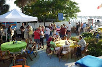 The marina threw a big “thank you” bash yesterday for all the folks here in the marina and anchorage. Crowd looked to be over 200 strong. There was lots of catered food, a live band and dancing. Mother nature smiled on us and gave us lots of sunshine and softer breezes for the late afternoon event. Everyone had a great time.
 Donna’s birthday present arrived today (3/31). Her bday isn’t until 4/12, but she wanted this Razor Scooter real bad after riding on our friend Don’s. Sure made my shopping real easy…thank you Amazon.com.
That’s about it for now. BTW, it’s finally getting to be near normal Florida weather and it’s time to head home. We’ve sort of set a drop dead date for departure NLT April 12th. It may be sooner, depending on the winds and weather. More to follow later.
Donna is still doing knitting and crocheting to occupy her time. Me, I’m starting to do some boat projects as time is growing short before we will be heading home. The new Rocna anchor arrived and I got it attached to the chain rode and mounted. The problem now is where to store the Danforth anchor that the Rocna replaced.
.jpg)
 I finally ordered the solar panels and they arrived real quick as they came from eMarine near Ft. Lauderdale. Naturally the weather wasn’t too cooperative in providing calm days for hanging off the stern to install the mounts and panels. Got them installed just in time to see them work before we took a road trip down to the Dania Beach Marine Flea Market.
We rented a car for a week so we could go to the Flea Market and to the Winter Park Art Show. We took Walter and Maggie with us to Dania Beach. The Flea Market was like most… lots of stuff, but very little of anything you were interested in. Still, it was a fun day.
We drove to a “touristo” hotel near Orlando on 3/19. We arrived late in the afternoon after a lousy trip. We were the unfortunate object of a hit and run driver in Kissimmee, Fl. We weren’t hurt and damage to the rental car was only a scratched bumper. We spent an hour and a half just getting a police report. What a bummer!

Well, here it is the last day of March and I’m still working to finish this update. That’s not the only thing that needs attention…still haven’t finished filing our taxes either.
I’ve started doing some pre-departure chores like change the engine oil and filter, change out the fuel filters, run through the safety equipment checklist, etc, etc. One last fixit job to do is change out the dead cooling fan in the refrigerator compressor unit. I’ve put it off because the temperatures have been low, but as the weather begins to get warmer, the fan becomes more important.
Donna has been busy making “trading stuff” for the artist retreat she will be attending at the end of May. The project consumes most of the salon at times. I guess it’s a good thing Buddy and I don’t take up much room. Hah!


That’s about it for now. BTW, it’s finally getting to be near normal Florida weather and it’s time to head home. We’ve sort of set a drop dead date for departure NLT April 12th. It may be sooner, depending on the winds and weather. More to follow later.
February Update - 28 Feb 2010
 Let’s see, what do I tell you about our activities? First I’ll tell you about the miserable and uncharacteristic weather we’ve been experiencing. Unfortunately the weather scenario seems to be affecting the entire country's activities this winter.
Instead of the usual low to mid 60s at night and mid to upper 70s during the day, it feels like we’re living in an icebox. Night time temps have been in the 40’s with a few extreme nights in the 30s. Daytime temps are only in the 60s. Its not exactly what you traveled south 1000 miles for. About once every two weeks or so we get a warm, bright sunny day with temps in the mid to upper 70s. Only then do we break out the short, t -shirts and sandals.
Donna has forsaken some of her art and craft work and taken to doing knitting and crocheting. That’s how cold it is! It had been so long since she had done those things, she had to teach herself how all over again.
I haven’t done much in the way of work on my list of boat projects either. The dinghy still needs the floor re-glued, we’re still waiting on a hose for the engine and negotiating prices for adding solar panels. We did make several “boat” purchases this month. First we purchased an Alfa WIFI adapter and now have excellent WIFI reception on the boat. Second, we went to the Miami Boat Show and got a new foul weather jacket for me and a Rocna 33# anchor. Maybe now I can stay dry now and sleep better when we are anchored out.

 Despite the chilly weather, the trip to Miami with Walter and Maggie was a lot of fun. Walter drove us down early Saturday morning and we went straight to the boat show. We looked at a bunch of the new sailboats and talked with lots of accessory vendors. After the show we went to a motel over in Kendall to spend the night. We also went to Kegs, a locals hangout, played pool and had dinner. The next morning we took advantage of the motel’s free breakfast and then went to Coconut Grove for the big art show. Donna and Maggie cruised the art exhibits, while Walter and I mostly walked along and talked boat stuff. It was a great weekend, especially the sleeping in a warm roon with a real bed.
Oops, almost forgot mention one other important purchase. We got tired of lugging around the big camera and trying to keep it from getting wet. Consequently, no pictures of our activities. So…we got a new pocket sized digital camera. It’s easy to use and carry around so hopefully we will be able to put up more pictures on the blog.

The “Buddy” report finds him well and a bigger PITA than ever. He’s up a daybreak wanting to be fed and allowed out on deck. Turn you back and he’s in the dinghy. He even expects a clean litter box every time he needs to use it. And complain about the weather…Sheez, he gets really vocal, like now when its cloudy and the wind is blowing 25+ and he can’t sun himself on top of the bimini. He sort of yells and looks at you with a “why don’t you do something about this” look.
That’s about it from chilly FL. More to follow later.
January Update - 31 January 2010
We’re getting complaints from friends and relatives wanting to know why there have been no updates to the blog. Once again I must apologize to everyone for not posting more frequently.
Life in paradise isn’t all parties and fun although there is a some of that too. Things we take for granted at home become real chores while living on a boat. Take for instance, flushing the toilet…at home you press the lever and if you haven’t overloaded the bowl, everything disappears down the drain and you never think of it again. Out here on a mooring, when you pump the bowl empty the contents are transfered into the boats holding tank. Unlike the sewage system at home, the tank doesn’t have near infinite capacity. After a while that tank gets full and must be emptied. Believe me, this is not a chore to be neglected. Read on to see what this little task requires.
First you need a day with the wind speed and direction are appropriate for a safe or easy docking approach. Then you get out the binoculars and check to see if the pump out facilities at the dock are clear. If they are a quick call on the radio to the marina office will usually get you clearance to proceed. Next you start the engine and prepare to leave the mooring ball by lowering the dinghy and moving it forward to the bow where you tie it to the mooring ball. This makes it easier to catch the mooring line when you return. Then you cast off the mooring lines and motor about a quarter mile to the pump out dock. When you arrive, if you are lucky, there will be a dock hand available to help you tie up to the dock.
Once secured to the dock, you commence the pump out process, which essentially entails using a big vacuum hose to literally suck the tank empty. Once that is done it’s a good time to attach a your “drinking water safe” hose to a water connection on the dock and fill up the domestic water tank on the boat. With that done its time to return to the mooring ball. Again, if you are lucky, the dock hand may help with your lines, otherwise you’re on your own.
Motoring back to the mooring you always seem to encounter different wind/current conditions than when you departed. Approach to the ball must be dead into the wind and slow enough to allow the bow person to grab the mooring line, get it aboard and get your bow lines secured to it. Miss the ball grab and you’ll have to go around and try again. Second and third tries bring out big audiences on neighboring boats out to watch the folly. Once the boat is secured to mooring ball, you move the dinghy back to its usual position, tied to the stern cleat.
Let’s see now, somewhere between an hour and two hours have elapsed and you have managed to take on 50 gallons of water, get rid of 20 gallons of sewage. Just think, at home you turn the faucet and press a lever to do the same things. Oh, well only 7-10 days until we do it all again.
Lets see, there has to have been some more interesting or fun stuff during January.
I know…the weather, we can always talk about the weather. The whole east coast got an artic blast and we suffered for two weeks in bitter cold for Florida. Record night time lows in the 20’s and 30’s were set and also a record for the number of continuous days with temperatures never exceeding 45. We consumed copious amounts of denatured alcohol using the stove just to put some heat into the boat. Our gas consumption for the Honda generator also increased as we also used a small electric heater we have onboard. I caught the bus and went to Wal-mart where I purchased two sleeping bags so we could zip them together and sleep warm and toasty, me, Donna and Buddy. The cold had a real bad affect on some species of fish in the river too. We saw lots of them swimming upside down at the surface and then dead a day later. Someone estimated the weight of one near the dinghy dock at 150 lbs. This wasn’t like the weather we experienced on the last trip.
Walter and Maggie invited us to attend a Mardi Gras costume party at their condominium one Saturday Night. We all dressed as gypsies, carried little instruments and went as a Band of Gypsies. There were lots of hors d'oeuvres
and wine, then a sit down dinner and dancing afterward. We didn’t win the costume contest, but we did have lots of fun.
We’ve been making good use of the folding bicycles this trip. We’ve mastered the art of balancing bags of groceries hanging from the handle bars on our trips to Publix for groceries. I even found the max carrying load on the rear platform…a 18 pack of beer. Riding along Federal Highway is a little daunting though. Crossing intersections with right turn lanes are the most dangerous. We stick to the sidewalks where ever possible and even walk the bikes across some intersections using the pedestrian crosswalks. Riding the side streets is much more pleasant.
Our friends Fred and Phyllis stopped by for a short visit one weekend. They were on their way to Miami to catch a big cruise boat for a trip to the western Caribbean. We enjoyed margaritas and noshes in the cruisers outdoor lounge area, walked through the shops along Osceola Street and then dined at Flannigans, one of the local watering holes. Afterward, they took us to Wal-Mart which helped us re-supply the boat with a couple of heavy items…cases of beer and bottled water.
Jan 2 - The New Year
Happy New Year to everyone. We’re still here in Stuart, FL. We got a few days of typical FL weather and really enjoyed the warmth on New Years Day.
They have a “meet and greet” with all the boaters every Tue, Thur and Sat at 1645 hours. We attended the New Years Eve get together and carried ham salad and crackers to share. Thank goodness it was all consumed. The eight pounds of Christmas ham is finally history. The turnout was down as lots of people are still away for the holidays, but the crowd numbered about thirty and included people from just about everywhere. We said so long and headed back to the boat around 2100 with thoughts of returning around 2300 to celebrate the new year with the party crowd. Back at the boat it didn’t take long for sleep to overtake us and I awoke with only about twelve minutes to go before midnight. I woke Donna, we rang in the new year and then went to bed. No late night party for these wimps.
I guess that was a sign of how our New Years day activities were going to progress. A planned visit to Wahoo’s for happy hour and customer appreciation food got canceled when Maggie couldn’t make it. So for excitement we started on a 500 piece puzzle (darn you… I mean, thank you Shirley G.) We were about half done with the puzzle when we lost our warm weather. It turned cloudy and a cold front blew in (20- 30 mph winds) near sundown.
We awoke to 52F inside the boat and predictions of only lower 60’s for the day. Actually things are expected to be that way for several days. Maybe we need to go south for the winter.
Subscribe to:
Posts (Atom)