We’re up early with coffee and a breakfast bar to start the day. We get underway at 0620 hoping to make all the bridges before the late afternoon opening restrictions. Unfortunately, all the fast powerboats had the same idea. A few got going before us, but we had to put up with all the others passing/waking us the rest of the day.
The overcast skies gave way to partly sunny and then sunny as we got into Virginia waters. We arrived at the North Landing Bridge a few minutes early and had to jockey about. Once we cleared the bridge, the race was on to make the rest of the scheduled openings at Centerville, Great Bridge, the lock, Steel Bridge and Gilmerton.
At the lock we were the last boat in and were forced to take a port side tie up. There were no line handlers to help and we struggled to get lines on the cleats. Being the last boat out of the lock, we kept the RPMs up as we raced to make the Steel Bridge opening.
After clearing Steel Bridge we ran into a show stopper at the #7 railroad bridge adjacent to the Gilmerton. The normally open RR bridge was down and they were doing maintenance. Ten boats jockeyed about for over thirty minutes before maintenance crews announced they would open. We cleared the RR and Gilmerton and continued on.
The skyline had changed only a little. The one glaring difference was the absence of the old Jordan Bridge. It wasn’t totally gone, but the span, counterweights, and half of one tower were gone. In fact, welder/burners were cutting away on one tower as we passed by.
When we reached our dock, the transmission refused to shift out of reverse and we crashed the dock stern first. We were going slow and suffered no damage except to my pride. We traveled 2000+ miles, made dozens of successful dockings or mooring approaches and then we hit the dock arriving at home. Audience…you betcha!!! The whole world will know and remember not our cruising accomplishments, just our arrival home! Sheez!
Regardless, We’re HOME!
Location: PYC Dock/Home - Portsmouth, VA - MM 0
Distance Traveled: 50 mi
Total Boat mileage on return trip: 1058 statute miles
May 13, 2010 - Day 28
The predicted seas for the Albemarle was 1-2 feet with winds of 10-15 from the NE. Not a great forecast, but we decided to attempt a crossing of the infamous Albemarle Sound. Sometimes I think I’d like to take those NOAA weather guessers out to experience their predictions. We successfully negotiated the nasty shoals just north of the Alligator River Bridge and then began experiencing winds of 20 with higher gusts. Waves ran 3-4’ (seemed like mostly 4’) with a short period between making it a bone jarring, very rough and slow crossing. Donna stayed in the cockpit as conditions below were intolerable. Buddy took refuge in his cubby hole under the dinette next to the hull. Being at the center of the boat, he got lots of rocking action but wasn’t tossed about so much. Surprisingly, he did not get seasick today.
Conditions did not get much better until we reached the upper portions of the North River. The sky remained overcast and the temperature cool all day. It took a sweatshirt and my heavier foul weather gear to stay comfortable against the wind and spray. We heard several boats calling Sea Tow and Towboat/US for assistance during the day. Rough conditions seem to always increase the occurances of equipment failures.
When we reached the anchorage area at Buck Island, we decided to continue on to Midway Marina at Coinjock, NC. Doing so would put us about an hour and a half of travel time closer for tomorrows run home. Considering the number of restricted bridges and the lock to be timed, we needed that advantage.
We arrived at Midway Marina about 1600 and got a tie -up on the face dock. After straightening up the interior of the boat, we proceeded to the showers for a cleanup before dinner.
We went next door to Crabbie’s Restaurant for dinner. The service left something to be desired, but our NC BBQ dinners were delicious and plentiful. Back at the boat, we watched a little TV before we both fell asleep. What a day!
Location: Midway Marina, Coinjock, NC - MM 50
Distance Traveled: 34 mi
May 12, 2010 - Day 27
We awoke early (thanks to Buddy) to a beautiful morning. The temperature was in the mid 60s and the humidity had not started to climb. We took the time to enjoy a quick breakfast and then started the departure drill. The anchor was up at 0645 and we were on our way.
 It was a short run from the anchorage to the southern entrance to the Alligator River/Pungo River Canal. The canal is usually quite boring, but this morning we encountered a number of deer down at the waters edge on several occasions.
As we continued the 20+ mile run through the canal, the temperature and winds began to increase. When we reached the Alligator river around 1100, the wind was screaming 20+ out of the SW. This meant a lumpy ride up the river with the wind driven waves smacking the port quarter. It sure would be nice to get a decent day of sailing or motoring for that matter.
The weather report calls for storms and gusting (no kidding!!) winds as we approached the Alligator River Bridge. That triggered our decision to pull into the Alligator River Marina for the night. We reached the marina and are docked at 1515.
We find several boats from the anchorage the night before. Everyone had the same idea…avoid the afternoon storms and high winds. “Shingebiss” a trawler with friends we met at River Dunes pulled in about an hour later and we had a nice reunion chat.
A little wind down time, a nice dinner, a hot shower and we settle in for the evening hoping the winds are more favorable for our dash across the Albemarle Sound tomorrow.
Location: Alligator River Marina, NC - MM 84
Distance Traveled: 43 mi
May 11, 2010 - Day 26

We decide to try leaving anyway and get underway about 0745. The wind is blowing about 15 with gusts to 20 and we encounter 2-3’ waves as we reach the ICW. It’s better than yesterday, but not by much.
We hang tough and make the turn at Maw Point and enter the Bay River. We are now running with the wind and following seas. Rolling out the jib makes things are a little easier, but lots of howling below means Buddy has gotten seasick. Yuck!
When we reached the Hobucken Canal, things settled down for a while but the calm was short lived when we reached the Pamlico River. It was a 5+ mile run across the river and into the Pungo River. The turn up the Pungo provided little relief until we neared the town of Belhaven. The eastward turn at Belhaven provided the best sailing we had experienced all day.
When we reached the western end of the Alligator River/Pungo River Canal, we decided to anchor in a nearby anchorage for the evening. We found 4 other boats already in the anchorage but were able to squeeze in and dropped the hook at 1545.
Location: Pungo River, East of Belhaven, NC - MM 127
Distance Traveled: 47 mi
May 10, 2010 - Day 25
Departed the marina at 0745 and headed toward the ICW. Winds are really up. By the time we reach the ICW magenta line, the wind is blowing 20+ and gusting above 25. Waves are 3'+ and on the nose. We are only making 3.5 mph against the wind so I decide to return to Broad Creek and wait for this mess to blow itself out.
Location: Anchored again in Broad Creek, North of Oriental, NC - MM 174
Distance traveled: 7mi (but it doesn’t count)
Location: Anchored again in Broad Creek, North of Oriental, NC - MM 174
Distance traveled: 7mi (but it doesn’t count)
May 8 & 9, 2010 - Day 23 & 24
We awoke to increasing winds out of the SW and predictions of gusts to 25. We decided to move across the river to River Dunes Marina with its deeper water and protection.
We arrived there about 1030 and found several other cruisers hunkering down to wait for calmer conditions on the Neuse River. River Dunes is a “planned resort community” with a marina. The marina has all upscale amenities but is reasonably priced. It’s only negative is the approximately four mile run off the ICW route.
Location: River Dunes Marina, North of Oriental, NC - MM 17
May 7, 2010 - Day 22

I once overheard a fellow cruiser ask, “Will we ever get a favorable current?” Well today wasn’t the day either. The journey to the “non-tidal” zone was a battle today. As we traversed Core Creek and Adams Creek Canal the current was rushing towards the Beaufort Inlet. At one point our speed was down to less than 4 mph. Even the wind direction would not allow us to motor sail and assist our speed.
When we reached the Neuse River, it was apparent we were not going much further today. The wind was blowing 15+ from the NE and waves were 2-3 feet. A lumpy, not so pleasant Neuse awaited. So much for the “weather guessers” prediction of SW breezes. We motor jibbed across and as northward as possible. Then we turned into the wind and motored on to the entrance of Broad Creek. We entered the creek and headed to R4 and the anchorage there.
The water level in the anchorage seemed more shallow than in our previous visits. We were somewhat exposed to the NE wind, but conditions were tolerable. There were two shallow draft powerboats anchored further in and later, another sailboat anchored near us.
At dusk the wind switched directions and moved to the SW. This was not good as it moves water out of the creek and the water levels drop. We had anchored in 6.5’ of water which slowly became 5’ as the evening progressed.
Location: Broad Creek, North of Oriental, NC - MM 174
Distance Traveled: 26 mi
May 6, 2010 - Day 21
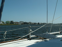
Around 0900 we started moving across the water to the town of Beaufort. We have always heard a lot of positive info from other cruisers about the town. To avoid the Beaufort bascule bridge, which was undergoing some maintenance, we took the main channel headed toward the inlet, then rounded Radio Island and headed back north into Beaufort.
 The anchorage was extremely crowded so we took a slip at the Beaufort Docks. The floating docks and dock side help made docking easy. After a little cleanup, we took a walking tour of the town.
 Front street has lots of restaurants and shops which liberated some of our wallet contents. The real interesting part of town starts in the block behind the “getcha” zone. There we found lots of historic homes, a graveyard, a couple of working artists’ studios and a maritime museum.
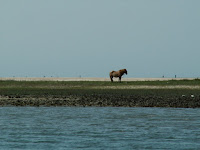 By mid-afternoon we had pretty much seen it all so we walked back to Front Street and had a late lunch at the Dock House Restaurant. It was a pleasant experience dining al fresco with views of the harbor, docks, and wild horses on the island across the harbor.
We did have a couple of negative experiences with the dock management. We requested a pump out as we were arriving and were informed the pump out dock was blocked by large motor vessel. They expected the boat to leave later. It didn’t leave and they let them continue to block the pump out service until the next morning. We were not the only customers denied pump out services. The other issue involved getting fuel. The advertised “fuel at your slip” was not to be had and required moving to yet another dock for fuel service. Most marinas have the pump out and fuel at the same dock.
As we were clearing our slip the next morning, the motor vessel finally moved off the pump out dock so we slipped in real quick, got the pump out and then moved over to the fuel dock to fill up.
Location: Beaufort Docks, Beaufort, NC - MM 200
Distance Traveled: 4 mi
May 5, 2010 - Day 20
More fog this morning. Visibility is about 1 mile when boats start leaving the anchorage. We weighed anchor and start moving north about 0720. One bridge to clear this morning at Onslow Beach. It was a struggle and I ran the engine harder than I like to but we make it to the bridge in time for the 0800 opening. There were nine boats jockeying about waiting on the old swing bridge to finally get fully open and then everyone took off.
 About a mile north of the bridge, the fog closed in and visibility drops to 150 yards. Suddenly nine boats came to a crawl. I had all my running/steaming lights on but cannot see any lights on the boats ahead. I can barely make out the shape of the boat ahead of me and I am thankful to be the last boat in line. This is definitely when having radar would be helpful.
After 0930, the fog began to clear a little and we picked up speed. We struggled against the current as we approach Bogue Inlet and Swansboro. We entered Bogue Sound where the channel is narrow but fairly straight. We got a little breeze and did some motor jibbing. We soon crossed the tide line and begin fighting the incoming tidal current from the inlet at Beaufort.
Around 1100 or so, the wind turned cool and began to pickup. Fog began coming in and obscured the Emerald Island and Bogue Banks to the south. As the fog rolled across the sound toward us visibility got less and less. When we finally reached the Atlantic Beach Bridge, we could not see the land mass to our south.
Things looked better as we approach Morehead City. From the big channel I saw two sailboats at the Sanitary Restaurant dock. That meant 2 of the 3 so called “free docks” were taken. Having learned our lesson on the last trip, we avoided the shoaled small northeast channel and took the main channel to the port area and round Sugar Loaf Island to the Sanitary.
 Once docked we took a walk about town and explored the construction at the Municipal Dock area. The town is building a Shower/Restroom/Laundry facility next to the docks. This should make these docks another possible stopping area. We also checked out a few shops including a great upscale bakery/gourmet foods place.

 After the walk we dined at the Sanitary to qualify for the “free” ($10) slip usage. Next door at a newly opened place called Jack’s, there was quite a Cinco de Mayo celebration going on. A live band, lots of hot rod cars, custom motorcycles, and a celebrity of sorts. Mikey Teutul from Orange County Choppers and the TV show “American Chopper” was there with some of their custom bikes.

After 0930, the fog began to clear a little and we picked up speed. We struggled against the current as we approach Bogue Inlet and Swansboro. We entered Bogue Sound where the channel is narrow but fairly straight. We got a little breeze and did some motor jibbing. We soon crossed the tide line and begin fighting the incoming tidal current from the inlet at Beaufort.
Around 1100 or so, the wind turned cool and began to pickup. Fog began coming in and obscured the Emerald Island and Bogue Banks to the south. As the fog rolled across the sound toward us visibility got less and less. When we finally reached the Atlantic Beach Bridge, we could not see the land mass to our south.
Things looked better as we approach Morehead City. From the big channel I saw two sailboats at the Sanitary Restaurant dock. That meant 2 of the 3 so called “free docks” were taken. Having learned our lesson on the last trip, we avoided the shoaled small northeast channel and took the main channel to the port area and round Sugar Loaf Island to the Sanitary.


 After the walk we dined at the Sanitary to qualify for the “free” ($10) slip usage. Next door at a newly opened place called Jack’s, there was quite a Cinco de Mayo celebration going on. A live band, lots of hot rod cars, custom motorcycles, and a celebrity of sorts. Mikey Teutul from Orange County Choppers and the TV show “American Chopper” was there with some of their custom bikes.
 Location: Sanitary Restaurant Dock, Morehead City, NC - MM 205
Distance Traveled: 39 mi
May 4, 2010 - Day 19

Light drizzle started about 0500 this morning and things went down hill from there. By the time it would have been getting light, fog settled in and visibility was way down. A check of the internet radars said more heavy rain was to come.
We decided to take the day off. We enjoyed a leisurely breakfast with a great omelet and lots of hot coffee. Later Donna worked on her art stuff while I made log entries.


Location: Still Anchored in Mile Hammock Bay, NC - MM 244
Distance Traveled: None
May 3, 2010 - Day 18
We got a late, 0730, start today. I wanted to be underway at 0700 so we could time the bridges we had to transit. The late start caused us to arrive early/late at the Wrightsville Bridge. I tried dragging my heals by idling the engine back and even idled back and put the transmission in neutral. The wind was directly behind us blowing 18, gusting to 22. Add that to the favorable current and the boat was traveling at 4.3 mph with no engine or sail help.
 Arriving at bridges with lots of wind and current is no fun. Heading into the wind/current with just enough speed to keep the boat near stationary is not too hard. But when you get inexperienced skippers or big powerboats who cant idle low enough, it becomes a dance of sorts as you try to maintain position and dodge boats out of control.
After getting through the Wrightsville Bridge, we played the same game again trying unsuccessfully to arrive just in time for the opening of the Figure Eight Island Bridge. After watching us jockey around for about 15 minutes in wind gusting 24, the bridge operator said he would try to open the creaky old swing span early. By the time he got it open, it was at the normal scheduled time.
The next bridge at Surf City was 18 miles away. The GPS estimated with our speed we would be either 20 minutes late or 40 minutes early depending on how you looked at it. No amount of sail trim and safe throttle could get us there any faster so we settled back and dragged our heals again.
 When we got to our anchorage destination, Mile Hammock Bay, there were already 5 boats anchored. We found a spot and dropped the hook at 1630. The bay is a basin dredged out by the Marine Corps for use with Camp LeJune. By 1800 three more boats joined the anchorage making a total of nine boats (make that ten counting the permanent resident). Considering the high wind situation (20 gusting to 24) we all needed maximum swing room.
The wind stayed strong until sometime after 0130. The Rocna held firm with a 5:1 scope.
Location: Anchored in Mile Hammock Bay, NC - MM 244
Distance Traveled: 51 mi

After getting through the Wrightsville Bridge, we played the same game again trying unsuccessfully to arrive just in time for the opening of the Figure Eight Island Bridge. After watching us jockey around for about 15 minutes in wind gusting 24, the bridge operator said he would try to open the creaky old swing span early. By the time he got it open, it was at the normal scheduled time.
The next bridge at Surf City was 18 miles away. The GPS estimated with our speed we would be either 20 minutes late or 40 minutes early depending on how you looked at it. No amount of sail trim and safe throttle could get us there any faster so we settled back and dragged our heals again.

The wind stayed strong until sometime after 0130. The Rocna held firm with a 5:1 scope.
Location: Anchored in Mile Hammock Bay, NC - MM 244
Distance Traveled: 51 mi
May 2, 2010 - Day 17
This was going to be a short day as far as traveling was concerned. The plan is to ride the incoming tide up the Cape Fear River and through Snow’s Cut. We departed at 0930 (about 2 hours before high tide) and got out into the river. Once we were out in the current our speed jumped from 6.0 mph to 9.7 mph. It was an easy run over to Carolina Beach where we anchored about 1200.
 Being for the first to arrive, we had the anchorage area to ourselves. Things were pleasant for a while and then the winds began to pipe up. At 1500, the wind was gusting to 25. Thankfully, the Rocna was holding firm according to the GPS.
Location: Anchored at Carolina Beach, NC - MM 295
Distance Traveled: 14 mi

Location: Anchored at Carolina Beach, NC - MM 295
Distance Traveled: 14 mi
May 1, 2010 - Day 16
We took it easy this morning and waited for the tide level to rise a bit. We were only going a short distance to Southport and I did not want to start the day by running aground on the bar going out the harbor or several of the inlets ahead. We got underway about 0930 and headed for two notorious troublespots, Shallote and Lockwoods Folly Inlets. These inlets were dredged recently, but are reported as shoaling again already.
 We arrived a little early for the scheduled opening of the Sunset Beach Pontoon Bridge. It's another very old bridge being replaced with a new high rise span presently under construction. I wonder if it will stay in place after the new high rise is completed?
Our timing with the tide provides us with plenty of water and we transit the troublespots easily. It being the weekend, we were bothered more by the local traffic. Using the autopilot was near impossible as we got waked from both sides as boats literally flew by us in both directions.
The wind is really up and out of the SW so water depths seem to be below normal. This means anchoring in Dutchman Creek or the Pipeline Canal are out of the question. We head on to the limited anchorage in the old Southport basin and the free docks at the Provision restaurant. Unfortunately we are late arrivals and those areas are already filled by other boats. With our cheap choices exhausted, we contact Southport Marina and take a slip there for the night.
We are docked by 1500 and decide to use the remainder of the day for doing laundry and taking showers. While doing laundry, we encounter a couple of retired ministers we met in Stuart. They are doing the Great Loop on board a large houseboat. It was great to sit and talk with them again.
The evening was pleasant and we both fell asleep watching TV, then got up and went to bed for the night.
Location: Southport Marina, Southport, NC - MM 309 (N of Myrtle Beach, SC)
Distance Traveled: 37 mi
April 30, 2010 - Day 15
No overnight happenings to speak of but we had more fog this morning. In fact, at 0600 when I got up, I could only see the mast of the other sailboat sticking above the fog. We decided to have coffee and a regular breakfast while we waited for the fog to lift. The fog cleared out enough to hoist the anchor and get underway about 0815.
 We continued our scenic tour of the Waccamaw until the ICW branched off into the cut toward Myrtle Beach and the Little River. The cut is narrower and littered with “blue collar pieces of heaven” and overstated opulence. Bridge operators at Socastee, Barefoot Landing and Little River did their best to slow us down by making us wait 10 to 15 minutes for each opening. These are tired old swing bridges and have all been replaced by nearby high rise bridges. I’m sure the justifications for building the new bridges included getting rid of these decrepit swing bridges. Why are they still in existence?
As we are departing Myrtle Beach we hear chatter on the VHF regarding the number of boats in the Calabash Creek anchorage. This was to be our destination but it was already crowded so we opted to stay at the Myrtle Beach Yacht Club.
The tide was low and water depths into the harbor basin were very skinny. Darn near heart stopping at one point. Even at the dock we were very close to sitting on the bottom. We refueled and prepped the boat for the next day and then hit the showers.
 We were both a little tired so instead of fixing dinner, we decided to go to the Officer’s Club Restaurant. We were presently surprised. The atmosphere and food were great. We both had excellent meals. We had crab stuffed mushrooms, steak, and shrimp scampi,. We even decided to have desert and enjoyed a “Brownie Tower” with coffee. After the fabulous meal we walked a bit and then headed back to the boat near 2200.
It was a quiet evening dockside.
Location: Myrtle Beach Yacht Club, SC - MM 346 (N of Myrtle Beach, SC)
Distance Traveled: 43 mi

As we are departing Myrtle Beach we hear chatter on the VHF regarding the number of boats in the Calabash Creek anchorage. This was to be our destination but it was already crowded so we opted to stay at the Myrtle Beach Yacht Club.
The tide was low and water depths into the harbor basin were very skinny. Darn near heart stopping at one point. Even at the dock we were very close to sitting on the bottom. We refueled and prepped the boat for the next day and then hit the showers.

It was a quiet evening dockside.
Location: Myrtle Beach Yacht Club, SC - MM 346 (N of Myrtle Beach, SC)
Distance Traveled: 43 mi
April 29, 2010 - Day 14
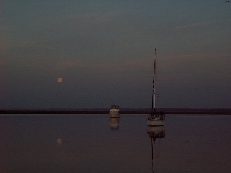
Big moon shining all night gave us a beautiful view of the anchorage. It also helped us keep our visual location reference points. Two other boats with us in the anchorage overnight, one trawler and one sailboat. The wind died way down late in the evening so we had a peaceful night. This morning however, we had a little bit of fog. I got these great pictures of the moon setting and the sun rising within minutes of each other. We delayed our start a little, but we were underway at 0815 headed for the scenic Waccamaw River and Myrtle Beach.
 We got some boost from the current until we reached Winyah Bay. From there we fought the strong current coming down the Waccamaw. The wind was light and from dead astern until late in the afternoon. By the time the wind began to increase, we decided to stop short of our goal and anchor in Thouroghfare Creek to take advantage of the trees that provided some wind protection there.
We shared the anchorage with one other sailboat. We dropped the hook about 1615 and found out why its called “Thoroughfare”. There was lots of local traffic running between the Waccamaw River and the Great Pee Dee River plus the usual local fishermen, skiers and jet skis.
Thankfully, the wind and traffic died a little after sundown and we had a quiet evening.
Location: Thoroughfare Creek, SC - MM 389 (N of Georgetown, SC)
Distance Traveled: 47 miles
Subscribe to:
Posts (Atom)